Showing posts with label Driving. Show all posts

Wednesday, July 8, 2015

A Connecticut Road Trip | Route 169

ROAD SIGNS, ROUTE 169

If you, like me, occasionally open the Twitter app and scroll a bit before becoming despondent at the state of the world and quickly opening Instagram to stare at photos of kittens instead, you may have become dimly aware of a recent WalletHub article titled 2015's Best and Worst States for Summer Road Trips.

The piece, which enjoyed a flurry of  re-tweets and was cited in a bunch of local news reports, ranks US states from 1 to 50 for their supposed road-trip-ability. It is hilarious, as you might expect from travel advice dispensed by a personal finance writer. But the part that particularly amused me was the (entirely expected and entirely inaccurate) assertion that of all the 50 states, Connecticut is the worst for exploring by car.

To refute that silly claim (not that it needs to be refuted), I thought I'd write a little post about one of my favorite Connecticut drives, Route 169. This National Scenic Byway is only 32 miles long, but it winds through some of the prettiest of the state's countryside - an area the Federal Highway Administration calls "one of the last unspoiled areas in the northeastern United States."

As you travel from Lisbon to Woodstock, you will see: centuries-old stone walls crossing green fields that rise and dip like waves; Colonial-era houses and red barns; time-worn headstones in historic cemeteries; horses grazing behind wooden fences; agricultural fairgrounds; antique stores filled with tempting odds and ends; farms and farm stands offering fresh eggs, honey, vegetables, fruit, flowers, and maple syrup; small towns barely changed from when they were settled in the 17th century, except for the addition of cute coffee shops and highly acclaimed restaurants; local museums, historical societies, and carefully preserved buildings; and, of course, that two-lane road, stretching out ahead of you like an invitation.

You can see much more than that, of course; it only depends on how much time you have. Plus, there's no rule that says you have to stay on 169. Turn off on any of the other numbered routes you encounter, and you'll find even more sights to make you LOL at the idea that anyone thinks Connecticut is not road-trip worthy.

AMERICANA, ROUTE 169
SCRANTON'S SHOPS, WOODSTOCK
TYPICAL QUIET CORNER VIEW, POMFRET
CEMETERY, LISBON
ROAD SIGN, CANTERBURY
SILO, POMFRET
OLD GAS STATION, BROOKLYN
LAPSLEY ORCHARDS, POMFRET
ANTIQUE STORE, BROOKLYN
ROADSIDE FLOWERS, POMFRET
COW, WOODSTOCK (THERE ARE REAL COWS TO BE SEEN TOO)
GRANGE HALL, WOODSTOCK
ROAD SIGN, WOODSTOCK
OLD POST OFFICE, WOODSTOCK


If you want more about Route 169, here are some additional resources:

A map of the route from byways.org.

A partial list of attractions from Mystic Country.

An itinerary (fall foliage themed) from ctvisit.com. 

A recommendation from Yankee Magazine.

Some history from kurumi.com. 


And here are some earlier Size of Connecticut posts about just a fraction of what you can see and do along the way:


If you want to add something else on to a drive on Route 169, consider these two former mill towns: Norwich, at the southern end, has museums, parks, and an eclectic city feel, and Putnam, at the northern end, has shopping, dining, and a classic small-town atmosphere.


Friday, July 26, 2013

FWP Tour 1C (+ Naugatuck)

It's been a while since I last posted a Federal Writers' Project tour. I haven't abandoned them; they're some of my favorite posts to write. They just tend to take forever. And I don't always have forever. But something made me check what number tour I'd gotten to, and I found that it was 1C, from New Haven to Naugatuck. That was only 16.5 miles! I could do that in far less time than forever.

The problem is that the route from New Haven to Naugatuck (Routes 67 and 63 in 1938, just Route 63 today) has changed. The Guide speaks of a roadside millstone, a relic of "one of a few stone tanbark mills, powered by oxen, ever used in New England" in New Haven. It describes "pastureland fragrant with sweet fern, juniper, and bayberry." In Bethany, it promises an "aviation field" and a mink farm.

You probably did not need me to drive the 20 minutes, or however long it took, to tell you that those sights are either gone or very well concealed these days.

But when I got to the end, where Route 63 "continues past the factory lined Naugatuck River," I found...Naugatuck!

I'd been to Naugatuck more than once before, but I had technically only been through Naugatuck. I'd never stopped to look.

Naugatuck is a consolidated borough and town, Connecticut's only such arrangement. (There are many consolidated city-towns, but it's confusing enough as it is without talking about those.)

Parts of Naugatuck are reminiscent of other Connecticut municipalities. Green with civil war monument? Check. Heavy red buildings, many of them churches? Check. Evidence of former grandeur funded by the production of decidedly non-glamorous commodities? Check. (Corporate donors to the Naugatuck Historical Society are classified as Button, Chemical, or Rubber level.)

But the way Naugatuck combines all these features is unlike any Connecticut town (or borough, or city) I've seen. (I think there are still a few I haven't been to, but I've been to most.) The way Naugatuck is laid out, and its appearance generally, escapes easy comparisons to other nearby places. I thought it would look like Derby or Waterbury or Danbury or Seymour but it doesn't, exactly. It looks like Naugatuck.

The layout of the streets is unexpected, and the design of everything from buildings to monuments to open space struck me as quite formal, dramatic even.

That might have something to do with the hills. These stairs (an unusual enough sight to make me wonder why you don't hear people talking about "those steps in Naugatuck" the way you hear about, say, Newtown's flagpole-in-the-middle-of-the-road) lead from one street at the bottom to another street at the top.

The one at the bottom is Route 63, which I (and the FWP guidebook writers) took to get here from New Haven. It's a steep hill itself, with a Dunkin' Donuts at the trickiest hilly bit. As I struggled in and out of the parking lot I amused myself by imagining John Winthrop going on about about a Dunkin' Donuts Upon a Hill.

Because that sort of thing becomes amusing when you read about Connecticut too much.

Monday, June 17, 2013

Parallel Lines

I think I speak for many people when I say I once thought Berlin was synonymous with the Berlin Turnpike, that soulless four-lane strip of sprawl that feeds into the Wilbur Cross. The Berlin Turnpike is boring, except for the occasional glimpses it affords of a past tackiness that's almost old enough now to classify as kitsch. Sometimes people get on it in the wrong direction and wreak havoc. (Sometimes these people are not wearing pants.)

But my assumption about the rest of Berlin was wrong. There is a Berlin that's not the Turnpike. If that seems hard to believe, the next time you end up on the Turnpike, take a slight detour along the parallel Worthington Ridge. This street, the backbone of the Worthington Ridge Historic District, is leafy and residential and quiet. You'll pass an old church with a white spire that towers above its neighbors, an eagle-topped obelisk of a veterans' monument, and house after perfect historic house that will make you think - though you couldn't have imagined it a minute ago on the Turnpike - that Berlin is almost idyllic.

There's this, too: the Berlin Free Library. It began its life in 1831 as the Worthington Academy, and was also used at various points as a church and a courthouse.

I took this picture from across the street, so you can't see this, but the sign in front reads: ICE CREAM SOCIAL. Doesn't knowing that make the building even better?

Friday, June 14, 2013

Around Candlewood Lake

I had a plan for this post. (I don't usually have a plan.) I was going to drive all the way around Candlewood Lake - the largest lake in Connecticut - take pictures of beautiful sights I saw, and not write very much. But what I found ended up being more fascinating than scenic. I mean, it was plenty scenic. But it was one of those cases where pretty pictures alone are not enough.

So, first of all, this is someone's backyard. A lot of people who live on the 60 miles of shoreline in one of the five towns that surround Candlewood Lake have backyards like this. I know, nice. But lurking 40 to 80 feet beneath the niceness is something ever so slightly not nice, because this lake was made by flooding forests, farms, and a village, called Jerusalem, in the valley below.

It was done in the name of hydroelectric power, though seeing it today you might guess it was done to increase the grand lists of Danbury, New Fairfield, New Milford, Sherman, and Brookfield. The creation of this 8.5 square mile lake was the first such project on this scale in America, and it worked: today the system of dams, turbines, and pumps not only generates power, but does so while looking like a lake so natural that it's hard to imagine a time when it did not exist.

This is the Connecticut Light & Power station in New Milford, where the tiny Rocky River meets the Housatonic. It's a startling building, industrial but sort of grand and gorgeous when you look at it closely. In the 1920s, CL & P had the power of eminent domain. Imagine those feckless executives who go on TV and dodge questions about why your power is still out and why they're doing nothing to fix it, back in the days when they had feck. Scary.

The Housatonic flows behind the station, and in front of it, across Route 7, is this penstock - or as I called it before I looked up the word "penstock," a FREAKING GIANT PIPE. Water is pumped uphill from the river into Candlewood Lake, where it is stored until more electricity is needed. Then it's allowed to flow down the FREAKING GIANT PIPE penstock again, generating more electricity in times of greater demand. If that makes no sense, read this short explanation by the American Society of Civil Engineers, and Steve's more entertaining exploration the history of the Rocky River plant at Connecticut Museum Quest.

The more I saw of Candlewood Lake, the more conflicted I felt about the whole story. On the one hand, there were those families who had to sell the land they had owned for, in some cases, hundreds of years. (A few of them didn't; some of the bottom of the lake is still privately owned.) On the other hand, the area was sparsely populated at the time, and to say the power plant and the lake helped the local economy would be a ridiculous understatement.

On the other other hand, whole swaths (literally) of history are drowned down there: streets, model T Fords, cemeteries (though the graves were relocated), and schools. On the other other other hand, it's amazing to think of a project like this succeeding in Connecticut today, or ever. Everything it would take to get this done - money, political will, cooperation, endless town meetings - just makes you shake your head and wonder how the people of the past managed to accomplish it. (Like Stonehenge or the Pyramids.) But they did it, and quickly - an idea in the spring of 1926 became a completed reality in the fall of 1928. And progress (and businesses with "Candlewood" in their names) came to this quiet valley. And for all that, it's still pretty darn quiet.

When you add it up the balance seems to tip almost entirely to the positive side, but on whatever hand I'm up to now, there's still something disturbing about it. And something amazing, too.

A good part of the area around the lake is simultaneously just what you'd expect and not what it seems. These cottages, for example, are not on the lakefront, and they're not vacation homes. They're basically just extended-stay hotel rooms on Route 7. And yet...adorable.

The breakout star of my circumnavigation of Candlewood Lake was Sherman, the triangular tip of northern Fairfield County. Sherman has a population of less than 4,000 people in over 23 square miles. No one really ever talks about Sherman, no one brags of living here or writes of how appealing it is. Of course, if they did, more people might come, and that would ruin the appeal.

So I won't say too much about it, except it's the sort of town where you want to photograph all the buildings, not just the c. 1810 store and the Old Town Hall, but the library and all the houses too.

You can't drive along the entire shore of Candlewood Lake; little dead end roads and private land make that impossible. But you can make a general circle around its Rorschach-blob outline, and see the water glittering enticingly outside your window for long stretches at a time. And you can drive almost through the lake at one spot, or at least feel as if you are, thanks to a little causeway where the lake meets Squantz Pond. (Squantz was a chief of the Schaghticoke tribe, not some random German.)

You can dive in Candlewood Lake too, and see the lost world preserved at the bottom. But if you're not going to do that - and I know I'm not - a quick drive around will give you a surprisingly powerful sense of what's been created here, and perhaps also of what is gone.

Friday, June 7, 2013

Route 163

Is Route 163 barns and countryside, tractor-crossing signs, and mist rising over tall grass?

Is it rust and neon signs and broken windows and peeling paint?
Is it a reminder of those who traveled this way hundreds of years past?

Is it little Post Offices, general stores, the sun peeking from behind the clouds, and wreaths on church doors?

Is it narrow rivers, highway overpasses, truck parts and pizza and the remains of what's been torn apart?

Yes.

Monday, June 3, 2013

Road To Nowhere


Route 11 is an odd little half-highway connecting Colchester and Salem. It's only 7.6 miles long, but it seems longer, because when you're on it - especially if you're coming from more populated central Connecticut - it seems like you're being led deep into the wilderness. Also, when you're on it there's a good chance you'll be the only person on it. And then it ends, just like that, abruptly depositing you by these ghostly overpasses somewhere between Witch Meadow and Devil's Hopyard, and you wonder what the heck just happened.

Originally, there were supposed to be 8.5 or so more miles of Route 11, which would take it over these overpasses and all the way down to I-95 in Waterford. (This would allow you to skip Route 85, which is slower, but far less of a solitary experience than Route 11.) But that plan was abandoned in the early 1990s. Recently, though, there has been some discussion of finally completing the project, or at least discussing completing it some more.

Until that happens, Route 11 will continue to spit drivers out in the middle of Salem. Which is hardly the worst place to be spat out. Right there at the final off-ramp, you can find Panfili's, a farm stand with produce and pie and a fabulously wacky collection of...lawn stuff.

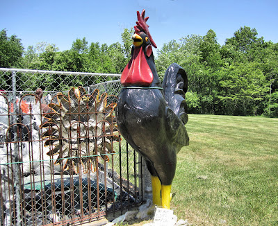
Like angels and sun-faces and roosters.

And ROOSTERS.

They also sell normal things for normal gardens.

And reminders that, contrary to popular belief, Connecticut also contains the rest of Connecticut.

And then, just a few seconds away, is Salem Valley Farms.

I don't know why every ice cream place in Connecticut makes this exact same black-raspberry-with-ginormous-chocolate-chips flavor of frozen yogurt, but I'm not complaining about it.

Wednesday, May 22, 2013

Oakdale Detour

There was a missed exit, then another, then a spontaneous change of plans, then a rain shower, then another change of plans, or maybe two. There was a detour, with police cars and flashing lights, and a parade, and a road I'd never been on, one that looked like every other rural Eastern Connecticut road, except everything on it was new. Even - especially - the things that were old.

Would I have found this church and its black and white doors without all of that disruption? I'll never know.

Monday, October 1, 2012

Tour 1 (4 of 4)

(Part 1, Part 2, Part 3.)

"At New London US 1 crosses the Thames River on a steel bridge that is sufficiently high to afford a view straight down New London harbor, one of the deepest on the Atlantic coast with more than three miles of navigable water frequented by seagoing vessels of many types."

So says the FWP guidebook for Connecticut, published in 1938. This is still true, except that the bridge is now the Gold Star Memorial Bridge, the twin pale blue spans that swoop high over New London, carrying I-95 as well as Route 1 over the river. My practice on bridges is usually to stare straight ahead and attempt to delude myself into believing there's no water below, so I didn't confirm the brilliance of the view.

On the other side, in Groton, the Guide goes into a tizzy over US 1 and US 1A and US 1 Alt, but in front of me plain old Route 1 just kept going, all by itself. I reached the Site of the 'Hive of the Averys' where a "dignified shaft" - in reality a somewhat ridiculous-looking bust atop a high pillar, like a decapitated Pilgrim on a pike - marked the location of the former Avery homestead (think Avery Point) home of generations of Groton notables.

I passed the "hamlet" of Poquonock Bridge, with its Baptist Church and fire station, the basis of many communities, it seems, as if all there is in life is to pray things don't catch fire and put them out when they do.

I came to West Mystic, which sounded suddenly like a fantastical location along the lines of West Xylophone. Drop the "West" and for some reason the make-believe aspect goes away too, and it's just old familiar Mystic. Which, the Guide informs me, the British during the Revolution called "a cursed little hornet's nest." If I were in charge I'd put that on all the village's welcome signs. I'd sell "cursed little hornet's nest" tote bags.

I've noted before that there's a conspicuous lack of Mystic on this blog, being both such a famous destination and so close to where I live. I'm waiting till it's colder to go back, when I can walk around taking pictures more freely and no one will care if I loiter on the sidewalk because all the tourists will be gone.

Well, all the tourists except me, I suppose.

East of the Mystic bascule bridge, almost too playful for a functioning piece of infrastructure, I eventually came to Mason's Island Road. Mason's Island was "presented to Captain John Mason of Windsor in appreciation of his victory over the Pequots." The statue of Mason that once stood near here has been removed to parts north, but eponymous his road and island ("sightseers are not welcome") remain.

Quiambog Cove, where there was supposed to be "an excellent view of Fisher's Island,"was as pretty as it must have been 70 years ago, and though the tour did not go through Stonington Borough, its description of the place - a "quiet old whaling port...on a peninsula, undisturbed by the rush of traffic" held up just fine.

Nearing the end of my drive I reached Wequetequock, one of my favoritely named Connecticut villages (two Q's! it's almost the Albuquerque of New England!) Wequetequock is so small that if you're not paying attention you can miss the fire station and the little lamp-post shaped sign and never know it's there.

You have to pay attention in Pawcatuck too, and make an effort to stop there, or else you'll get unwittingly whisked across the Pawcatuck river into Rhode Island.

But if you do stop, if you park as soon as you see the small downtown ahead, you might be pleasantly surprised, as I was the first time I came here.

On this day Pawcatuck was all red brick and red paint, a strong red that made the village look more solid and less an appendage of Westerly then it had before.

I could see Rhode Island just across the river, and that was the end of Tour 1. It was, also, however, the beginning of Tour 1J. But it will be a while before I get to that.

LinkWithin

Related Posts Plugin for WordPress, Blogger...