Showing posts with label Stratford. Show all posts

Friday, March 1, 2013

Under the Bridge


Sometimes, people are like, "can you drive me to Milford and then wait around for a while and then take me home again?" And I'm like, "OK, I guess I can walk around downtown and go into some shops and look at the duck pond or something." And they're like, "No, actually I have to go to northern Milford, up by the Merritt...but you can sit in the waiting room." And I'm like, "But I can't blog about a waiting room!" And then I look at a map of northern Milford and wonder to myself, what is up here, anyway?

The last time (OK, the only time) this happened to me, I stared at the blue stripe marked "Housatonic River" on the map for quite a while, wondering what to do with myself. Then it hit me. The Merritt crosses the Housatonic on a nice new-ish bridge, which replaced that old bridge with the terrifying metal grate that made it feel like you were driving across a rope ladder. Until it rained, and then it felt like you were driving across a rope ladder encrusted with ice. The new-ish bridge has a feature that confuses me every time I drive over it: a pedestrian walkway. Where might those pedestrians be coming from? I always wonder. And where might they be going?

Now, I could finally find out. Not the most scintillating activity in the world, but better than sitting in a waiting room. I drove to the Stratford side, near the Sikorsky building and the bizarre Boothe Memorial Park. The toll booth in that park once stood on this stretch of Parkway. (There is also a Merritt Parkway museum in a shopping center on this side, and CTMQ is on it.)

This is the Sikorsky Memorial Bridge. To get to it I followed the Sikorky Estuary Walk, which sounds lovely, but isn't. Maybe it's different in nicer weather, but in winter it's essentially a paved path with a large backyard on one side and an industrial-wasteland-slash-construction-site on the other. I was the only person on the Estuary Walk as it wound along past what looked like the place the DOT throws old road signs they don't know what to do with. Across the river a plume of white rose from a smokestack, and a MetroNorth train clattered by. Sirens wailed somewhere off in the distance, I didn't know where, I could no longer see the road. A helicopter hovered in the sky. The path curved under the highway, which rattled ominously as cars passed overhead, and led me to the little graffiti-covered corner above.

The Housatonic is gorgeous in places, excessively so sometimes, as if trying hard to compete with the State's better-known eponymous river. But not here. I made a note to remember this desolate, noisy place if I ever decided to take up a life of crime.

Eventually the walk circled completely around, past Sikorsky's fenced parking lot and onto the bridge. Now I was one of those odd pedestrians. I still didn't know why anyone would walk (or bike) along here, unless it was a part of a short, depressing commute.

There are views of the river from up on the bridge. But it's not worth it. Unless you want to say you've walked over the bridge and you will never do it again. Then it's totally worth it.

Wednesday, October 3, 2012

Point No Point


This is the view from the Point No Point walkway at Point No Point, in Stratford. To be honest I only came here because I wanted there to be a sign that said "Point No Point," because that just struck me as existentially hilarious. But there was no sign.

Well, there were signs. There was this one, for instance, and there was one I'm mad at myself for not taking a picture of, that said, "NO AN  ALS ON THE  EACH."

But there was no acknowledgement of what this odd little place - a truncated strip of public beach with a stone wall and a sidewalk and a parking area between two more restricted pieces of coast - was called.

The Stratford Point Light, painted in wide red and white stripes - the most toy-like and cheerful of lighthouse designs - is visible from here, at a disappointing distance.

The seawall is punctuated with these small open squares, perhaps to let water though? (Or perhaps to provide hiding spaces for official documents now that the Charter Oak is gone?)

As I walked past these massive boulders, overwhelming a small wooden fence, I thought absently to myself, "Hmm. Glaciers." That's the thing about Connecticut, about getting to know it. Before the half-formed question in your mind even poses itself, you answer it with thing like "glaciers." There are a few such go-tos for Connecticut questions. Glaciers. John Mason. The General Court. They mostly explain everything. But why is this called Point No Point? Who knows. And maybe that is the way it should be.

Update:  Point No Point (or Point-No-Point, if you prefer hyphens) was once a common way to refer to a point of land shorter than its two surrounding points. (According to...someone in Canada.) By way of Steve of Connecticut Museum Quest, who beat me to it by four years!


Wednesday, September 26, 2012

Oldest and Smallest and Stratford Again

I never thought I'd write more than one blog post about Stratford, but it's proving to be a continual font of surprises. For example, did anyone know that in Stratford there's a marker commemorating the oldest postal route in America? I'm not usually one to go looking for -ests, but I was right there, so I figured I might as well.

The DAR put up the marker in 1915, on the spot where (supposedly) a post rider on the first mail run, in 1673, paused between New York and Boston. There's nothing really unique about Stratford in postal history, as far as I can tell, except that they chose to commemorate this and other towns on the Post Road didn't. So OK, that's not the most exciting thing.

But wait! Because the stone is planted in the ground of...

...what Stratford claims is "Connecticut's smallest park." Connecticut's smallest park would naturally be quite small, but I think maybe not this small. This is, frankly, a traffic island on a road without traffic. Maybe there's a fine line between traffic island and park, but this doesn't quite come close enough in my opinion. It might get a very slight nudge toward the park end of the spectrum because a paved sidewalk runs through it at the wide end, but it's not a park. Would you sit on this on a folding chair and read a book? Would you say to someone, "I'll meet you at that park at East Broadway and Elm?" No, you would not.

However, it's doing better than the other Google result for "Connecticut's smallest park," because that is a) a State Park, and therefore in a whole different category, and b) in the middle of Gardner Lake. That's not a park, it's an island. And between a traffic island and an island island, I'm going with the one on land.

Wednesday, September 12, 2012

Tour 1 (Part 2 of 4)

Well, I thought I'd get lost in Bridgeport, but I didn't. In fact I did something even worse: I assumed I was lost when I wasn't. So I gave up and got on the highway, thinking of this line. But though I felt guilty for skipping a part of Route 1, since the Tour doesn't deal with anything in major cities anyway I convinced myself that it wasn't the worst part I could have skipped. I took a Stratford exit I was not familiar with and wound up, entirely independent of my own volition, where I was supposed to be.

Which wasn't Route 1. "US 1 enters Stratford on Stratford Ave. and turns left onto Main St.," the book says. Which is a lie. In reality, Stratford Ave. is Route 130, and Main Street is 113. I'd encountered this problem in previous Tours. Either Route 1 had been re-routed, or the FWP writers had gotten it wrong (maybe driving through Bridgeport had tired them out.) Or maybe, as I had amused myself imagining before, they just wrote this whole thing while drunk.

But whatever had happened back then, Route 113 was clearly the place to be. A long row of very pretty houses, not all of which were made of fondant like the one above, led to the town center. This area was a surprise to me, because my previous visits to Stratford were, as I've mentioned before, frequent but not at all varied.
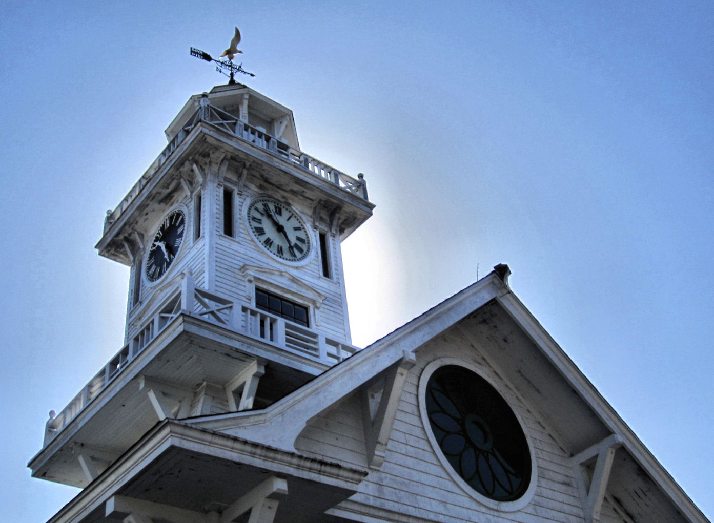
Everything the Guide wanted me to see was here on Route 113, including the first Episcopal Church in Connecticut, Christ Church, with its "weathercock from the spire of the original building, which still bears the bullet holes of British marksmen under Colonel Frazier who, when quartered here in 1757-58, amused themselves by using the chanticleer as a target."

When the Guide was written, Stratford had moved from "shipbuilding and oyster fisheries" to "considerable manufacturing." This part of it seemed to get by on historic buildings and little shops that made me smile for no particular reason. When those ran out, the road once again joined with Route 1 to cross the Washington Bridge over the Housatonic into Milford.

Or, I should say, Devon. Devon, like Lordship, is one of those place names you think exist only on highway signs. Except they all do exist. I crossed the bridge depicted in this mural and there I was, in Devon. Looking at this mural.

Now I was supposed to look for "the junction with State 122," which would lead me past "sandy flats where shore birds may be seen feeding. From the tiny bays and coves along this shore oystermen put to sea to harvest a crop from submerged lands..." This was either a FWP writer giving up, as I had with my Bridgeport detour, or simply a description of a lost world. But there was a place I knew that sounded sort of like this: Silver Sands State Park. It was Route 162, not 122, that dipped South into this fragile watery part of Milford, but I didn't care.

I suddenly wanted to revisit the elevated boardwalk of Silver Sands, where many years ago I'd had what seemed like hours of existential discussions that went nowhere, only down the looping boardwalk and back again. (Which reminds me that a good part of my teenage years were spent driving back and forth on the Post Road in the wee hours of the night drinking Dunkin' Donuts coffee.)

And perhaps because my life now has slightly more purpose, Silver Sands was nicer than I remembered. Though the oyster fleet that "flourished" here in 1938 has moved on.

Later I found that Route 162 had indeed once been Route 122. If Bridgeport and Stratford had broken my Sense of Connecticut (that's not exactly a title for a best selling book-turned-movie, is it?) then Milford had re-calibrated it.

I drove east, through Woodmont, "a summer colony" and borough of Milford where I glimpsed the promise of the water at the ends of the cross streets.

Then I was in West Haven, where upon reaching the "large Green which was presented to the town by Shubael Painter in 1711" I recalled I'd been before. West Haven is a bit like Wallingford. I have nothing bad or especially good to say about it, it just doesn't quite seem to belong, entirely, and - obviously - its central area is not particularly memorable. West Haven's history, though, was far more exciting, according to the Guide: once "the home of General Tom Thumb, celebrated midget," the town "was the scene of a raid by the British on July 5, 1779, when General Tryon brought 3000 redcoats ashore, pillaged the church, burned documents, and looted the town."

Next was New Haven, and the Shoreline beyond.

Monday, March 12, 2012

Stratford: Full Of Surprises. Yes, Really.

Growing up, I spent a lot of time in Stratford. Unfortunately it was mostly just in the office of a Stratford orthodontist. I wore braces for many, many years more than anyone should have to. Long after all my classmates had had theirs removed and were prancing about smiling like normal people, I was still placing little mini-rubber bands in my mouth and traveling frequently to Stratford to have my teeth painfully wrenched into straight lines. I was only able to have the braces at all because a relative of mine, who'd been an orthodontist in western Canada, once helped out another young would-be orthodontist. That man then moved to Stratford and had a son who also became an orthodontist and was willing to do my family a favor in return. If not for that most random of geographical coincidences, I'd probably have teeth that didn't even form rows, but just sprouted out haphazardly at crazy angles from all over my gums.

Anyway, despite the hours I racked up in Stratford in my youth, all I ever saw of the town itself was the distance between the exit ramp off I-95 and the orthodontist's reclining chair. And I think I thought that's all there was.

But land sakes alive was I wrong, because Stratford boasts one of the most surreal places I've been to in all of Connecticut. The little white structure above is a 1908 trolley station, and it's one of the more normal buildings you encounter at Boothe Memorial Park.

They are mostly all clustered together, making it difficult to think about one of the styles or eras represented without being instantly distracted by another one. Brothers David Beach Boothe and Stephen Nicholas Boothe basically began collecting all the weirdness they could find and amassing it on their property in the early 1900s. The whole thing was left to the Town of Stratford in 1949. I found it all sort of too much to deal with in a mature, adult way, and instead took to dashing back and forth between the structures and generally laughing at their absurdity like a six year old.
The full name of the place is Boothe Memorial Park & Museum. The museum part was closed when I went, but for the easily amused, the grounds are entertaining enough.

This claims to be the "oldest homestead in America," on the grounds that the c. 1840 house was "built on the foundation of the 1663 house, and continuously occupied." That seems a little dubious to me, but who cares: the site is undoubtedly historic, and in a state where historic is commonplace, it's also something less expected: wacky.

Take this, for example. This is the "technocratic building" (the plaque calls it the "technocratic cathedral" and notes that it was built c. 1932 out of redwood that was shipped through the Panama Canal.) What exactly "technocratic" means in the context of 20th century architecture (or anything else) I can't tell you, because I'm still pretending to be six.

This is the Clocktower Museum. The plaque says that "in 1913, this 1830s haybarn was topped with a clocktower which was acquired in Massachusetts by the Boothes in exchange for a carpet sweeper." As one does.


There is, of course, a windmill, because...why wouldn't there be a windmill.


It has a little padlocked door.
This is the carriage house, I believe.

There are several millstones, and other assorted old stone equipment, placed about the lawn like statues would be in other parks. By the time you get to them, they seem perfectly normal.

There's a rose garden too, pretty even in its dry, empty off season.

And a 1930s blacksmith's shop with 44 sides, which has to be an unusual thing in a building.

There's a replica lighthouse, which seems to have been built for a tank of six-foot goldfish.

And a little railway station which is, in fact, the home of the Boothe Memorial Railway Society and (I looked in the window) full of model trains. You don't have to be at all interested in model trains to be impressed with the amount of model train paraphernalia it takes to fill a whole small building.


There's also an observatory, belonging to the Boothe Memorial Astronomical Society.

And a defunct toll booth from the Merritt Parkway, when it used to have toll booths. (Who knew it had toll booths?!)

And some chickens. I guess just because...hey, chickens!

That's not even all of it.

And oh, yeah, the whole thing sits on 32 acres of lovely open space on the Housatonic, with picnic tables and children's play equipment and trees. Which would probably be notable all on its own, but which is an afterthought compared to all the rest of it.

Boothe Memorial Park is located in the northern part of Stratford, so unlike when I used to go to the orthodontist all those years ago, I took the Merritt. This meant that my return took me right past the headquarters of Sikorsky, outside of which is a large helicopter. Now, if I'd only seen that helicopter, perched where I least expected it, I might have been momentarily taken aback. But at that point I was inured to strangeness. "Oh, there's a helicopter," I said, and I drove on.

LinkWithin

Related Posts Plugin for WordPress, Blogger...