Showing posts with label Bridgeport. Show all posts

Wednesday, August 13, 2014

Shot Tower


This 1909 shot tower is essentially all that remains of the sprawling Remington Arms complex in eastern Bridgeport. The factory buildings around it have all burned or crumbled. Its broken windows are slowly being obscured by vegetation. I didn't attempt to get up close to see whether the two spiral staircases inside are still intact.

The shape of the 167-foot brick structure looks almost fanciful now; one might assume it was made this way because early 20th century people liked their buildings to convey a mixture of strength and whimsy. But its design was at least partly practical: inside, molten lead was dropped from up high and left to form spheres in free-fall, which landed in a basin of water at the bottom to cool.

Remington Arms no longer manufactures shot pellets, or anything else, here. They haven't done so for quite some time. It is strange that instead of looking out of place in the neighborhood, the shot tower is the only thing that seems to belong. The people walking by in its shadow, the small houses on the next block, the cars parked in front of them, and even the cemetery across the street, all seem lost.

Friday, August 16, 2013

"'Bridgeport?' said I..."

I quite enjoy taking pictures of white buildings - obviously - but after so many posts full of so many towns that look so much alike, I do start wishing more buildings around here came in other colors. And no, that faded barn red doesn't count. I want real colors, and lots of them, like someone walked into a paint store and said "Yes, give me them all."

For example: I recently came across some pictures of Burano, an island off of Venice in Italy where every little building is painted a different bright shade, and was transfixed. Living there must be like hanging out in a massive tub of colored sprinkles.

This is not exactly Burano; it's Bridgeport. But Captain's Cove, better known for its restaurant and bar on Black Rock Harbor, also has a string of lilliputian shops of various hues. It's such a nice change from all the sameness. And you don't even have to take a boat to get there. Although you could...


Wednesday, October 17, 2012

Mountain Grove

You may have driven past this gate, in Bridgeport just over the Fairfield line, and wondered what was inside.

Or may have known it was Mountain Grove Cemetery, but never bothered to go in. Because if you're not one of those cemetery people, what could be that interesting about a cemetery?

You really need to go in.

This place is seriously odd. And beautiful - peaceful and sprawling and grand, with trees and hills and little narrow lanes. But mainly just deeply odd.

P.T. Barnum is buried here, but more to the point he designed the place. It looks like what you would expect, once you that; it's a highly entertaining cemetery. Parts of it almost border on the sensational. It was built in the mid 1800s, so there's no sombre, Puritan, New England restraint like in older Connecticut graveyards.

This little fairy tale castle tomb is merely the tip of the outlandish burial iceberg. How can I explain how unexpectedly strange this place is? How about: at one point, while I was driving through, a Ke$ha song came on the radio. And it didn't occur to me for several minutes that that might be a just a little incongruous.

Wednesday, September 12, 2012

Tour 1 (Part 2 of 4)

Well, I thought I'd get lost in Bridgeport, but I didn't. In fact I did something even worse: I assumed I was lost when I wasn't. So I gave up and got on the highway, thinking of this line. But though I felt guilty for skipping a part of Route 1, since the Tour doesn't deal with anything in major cities anyway I convinced myself that it wasn't the worst part I could have skipped. I took a Stratford exit I was not familiar with and wound up, entirely independent of my own volition, where I was supposed to be.

Which wasn't Route 1. "US 1 enters Stratford on Stratford Ave. and turns left onto Main St.," the book says. Which is a lie. In reality, Stratford Ave. is Route 130, and Main Street is 113. I'd encountered this problem in previous Tours. Either Route 1 had been re-routed, or the FWP writers had gotten it wrong (maybe driving through Bridgeport had tired them out.) Or maybe, as I had amused myself imagining before, they just wrote this whole thing while drunk.

But whatever had happened back then, Route 113 was clearly the place to be. A long row of very pretty houses, not all of which were made of fondant like the one above, led to the town center. This area was a surprise to me, because my previous visits to Stratford were, as I've mentioned before, frequent but not at all varied.
Everything the Guide wanted me to see was here on Route 113, including the first Episcopal Church in Connecticut, Christ Church, with its "weathercock from the spire of the original building, which still bears the bullet holes of British marksmen under Colonel Frazier who, when quartered here in 1757-58, amused themselves by using the chanticleer as a target."

When the Guide was written, Stratford had moved from "shipbuilding and oyster fisheries" to "considerable manufacturing." This part of it seemed to get by on historic buildings and little shops that made me smile for no particular reason. When those ran out, the road once again joined with Route 1 to cross the Washington Bridge over the Housatonic into Milford.

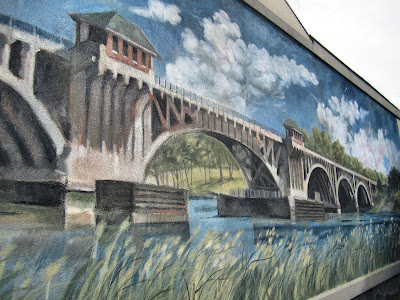
Or, I should say, Devon. Devon, like Lordship, is one of those place names you think exist only on highway signs. Except they all do exist. I crossed the bridge depicted in this mural and there I was, in Devon. Looking at this mural.

Now I was supposed to look for "the junction with State 122," which would lead me past "sandy flats where shore birds may be seen feeding. From the tiny bays and coves along this shore oystermen put to sea to harvest a crop from submerged lands..." This was either a FWP writer giving up, as I had with my Bridgeport detour, or simply a description of a lost world. But there was a place I knew that sounded sort of like this: Silver Sands State Park. It was Route 162, not 122, that dipped South into this fragile watery part of Milford, but I didn't care.

I suddenly wanted to revisit the elevated boardwalk of Silver Sands, where many years ago I'd had what seemed like hours of existential discussions that went nowhere, only down the looping boardwalk and back again. (Which reminds me that a good part of my teenage years were spent driving back and forth on the Post Road in the wee hours of the night drinking Dunkin' Donuts coffee.)

And perhaps because my life now has slightly more purpose, Silver Sands was nicer than I remembered. Though the oyster fleet that "flourished" here in 1938 has moved on.

Later I found that Route 162 had indeed once been Route 122. If Bridgeport and Stratford had broken my Sense of Connecticut (that's not exactly a title for a best selling book-turned-movie, is it?) then Milford had re-calibrated it.

I drove east, through Woodmont, "a summer colony" and borough of Milford where I glimpsed the promise of the water at the ends of the cross streets.

Then I was in West Haven, where upon reaching the "large Green which was presented to the town by Shubael Painter in 1711" I recalled I'd been before. West Haven is a bit like Wallingford. I have nothing bad or especially good to say about it, it just doesn't quite seem to belong, entirely, and - obviously - its central area is not particularly memorable. West Haven's history, though, was far more exciting, according to the Guide: once "the home of General Tom Thumb, celebrated midget," the town "was the scene of a raid by the British on July 5, 1779, when General Tryon brought 3000 redcoats ashore, pillaged the church, burned documents, and looted the town."

Next was New Haven, and the Shoreline beyond.

Wednesday, April 18, 2012

What, These Old Things?


This is the John Wheeler House in Black Rock, the oldest surviving house in Bridgeport. It was built in 1720, or possibly before, though 1720 seems to be the safe, agreed-upon date. The Wheelers were big around here; Thomas Wheeler, the area's first white settler, arrived in 1644.

What was then a trading settlement is now a pretty neighborhood near the water. I recall years ago people used to scoff if someone said they lived in Black Rock. Like "yeah, okay, you live in Bridgeport, poser." But seeing as the name was in use back in the 17th century, perhaps the scoffing was unfair. The area has changed quite a bit since the late '90s and early '00s, when my friend and I would occasionally find ourselves in Fairfield County, wonder what to do about it, and end up drinking margaritas at Taco Loco. (Happily, Taco Loco is still there. Its shaky-looking plastic walls have not yet been gentrified away.) Back to the Wheeler house. It was originally smaller, and has been modified over the years. And it's hard to see because the wind has furled it up, but I think that's a British flag on the pole above the door. Which adds a touch of Colonial era cred.

I wasn't even going to blog about this house but I felt I had to because I followed up on my post from last week and found the oldest house in Norwalk. And, well...

This is it. Really disappointing, right? The Thomas Hyatt House was constructed in 1677 but obviously changes and additions over time mean that if you miss the plaque - which you can't see from this angle- you'd never know it. It looked so anti-climactic I thought I had to show another historic house along with it. And then, while I was at it, I decided to add something even better than a house:

A c. 1790 Post Office in Weston. One of a few early Post Offices in the town, it became the official P.O. in 1883. It was also a general store. And there's a sign out front that indicates it is, or was at some point, a museum. The only evidence of this that I can find was that a museum was proposed for the site in the 1980s. But who knows? If you told me to guess which town had a secret museum that was reserved for the select few, Weston would be a good candidate. And anyway, what it is now is so much less interesting than what it was then.

Monday, March 19, 2012

To The Near The Lighthouse

Connecticut has, if I'm counting correctly, twenty lighthouses dotted along its Southern coast. Some are still operational, some are not. Of the twenty, one is a museum, two can be reached only by ferry (luckily for the unwashed poors among us, the Greenwich ferry is no longer restricted to Greenwich residents), fourteen are either not visible at all or visible only by (non-ferry) boat, and three are accessible to the public and can be reached on foot. One of those three is in New Haven, one I'm going to post about soon, and the other is the Fayerweather Island Light.

Fayerweather Island is located just off of Seaside Park in Bridgeport's South End. My directions to the park contained a line that every Jew wants to hear, "Turn right on Iranistan Avenue." I wondered what or who had inspired that unusual and slightly alarming name, but I learned the answer was less interesting - or more interesting, I suppose, depending on one's personal, um...interests - than I'd imagined. It involves P.T. Barnum, as the answers to most Bridgeport questions do. (What is that crazy building off the highway with the wacky little domes on top? The Barnum Museum. Why do they not announce what track the train is arriving on at the Bridgeport train station? Oh wait, that one has nothing to do with Barnum, never mind.) Barnum's Iranistan was a 19th century Oriental fantasy of a mansion that the showman and local politician had constructed in 1848. It burned down in 1857, but you can see what it looked like during its brief and ostentatious life-span here.

I didn't go all the way out to the little island, because getting there from the park requires a "mildly strenuous walk across a breakwater." It didn't look strenuous exactly, but it looked like something you probably shouldn't do in flats. Or maybe I'm just getting less adventurous in my old age.

I thought I was done with P.T. Barnum for the day after detouring into the origin of Iranistan, but it turns out he was largely responsible for Seaside Park too. It was his vision, and sits on some of what was his land. Before he started the process of turning this coastline, once "barely good enough for cows," into a public space, it was practically inaccessible. Some of it was underwater. The park is listed on the National Register of Historic Places - it was the first "waterfront rural park" or "marine rural park" in the country - and it was designed by Frederick Law Olmsted, Calvert Vaux and Egbert Viele, a team better known for their only other project together, Central Park.

This place is 375 acres, so I didn't try to see all or most of it. I didn't search for the Soldiers and Sailors Monument or the statue of Elias Howe, inventor of the sewing machine, or the one of Barnum himself. I just gazed out across the mile of beach, where a squabble of seagulls - or multiple squabbles perhaps - were gathered.

The low walls here, I decided, were safe to walk on in flats.

As I stood there, accumulating sand in my cuffs, the sun struggled to burn off the white fog that hung over the morning. It almost succeeded in producing a spring day.

Tuesday, September 13, 2011

Into the Woods


After the entertainment of Tour 1A, I decided to try Tour 1B: From Bridgeport to Junction with US 202. (I should probably go back and start with Tour 1, but it's so long. These little tours are easier to fit in when I only have a few hours.) But to start, I had to get to the place where "State 58 branches northeast from US1 at Bridgeport." 58, of course, is the Black Rock Turnpike, and getting to it involves that monstrosity of a multi-lane traffic circle where the Post Road and the highway and smaller, badly marked local roads strike out at odd angles. Then it runs up to the Merritt through a tacky-meets-affluent Chainstoreistan before reaching the promised "shady countryside." Then it passes the Samp Mortar Reservoir (I didn't know either) and the disturbingly large Hemlock Reservoir. As its blue water kept appearing to my right, and I thought it would never stop, I gazed through the scrim of trees on my side at the more solid mass of trees on the opposite bank. Eventually I turned right on what the book calls State 106 but what is now Center Road, into Easton Center. Above is the 1817 Congregational Church in Easton, "set high above the road in the traditional New England manner." (The traditional New England manner, I have concluded, involves making it as hard for yourself as possible in the winter.) Very close by, on Route 136, is the perfect little white Adams School House, which looks quite church-like itself, and is not on the tour.


I passed this road on the way to Easton Center and had to stop. Personally I think road signs like this evoke the lives of traditional New England people, even more than the churches. I just want to know if it was a large pig or a disdained woman who lived on this street. The building is typical of a lot of houses and barns I saw on this drive, tall and straight, perched high above the hilly road and set very close to its edge, as if they might tip over onto passing cars.


Easton has no cell service at all. I felt a strange sense of being lost to the world as my 3G turned to E turned to "searching" and then nothing, a flat line. It is a particular type of person who would choose to live here, one who likes massive houses and fantastic old barns and farm stands, and who wants to be technically close to major population centers but to feel as if they might be cut off, unreachable, for months. I have felt less out there (and less abandoned by AT&T) while driving through cornfields and prairies that were literally hundreds of miles from anything that could pass as a town.

I turned right off of 58 again, onto my best guess at "a side road," from whence the book said I could find "a little wooden bridge spanning an impressive 50-foot cascade." I did not find this, only remoteness and wind-slanted woods. Instead I went on into Redding, where I passed several small and humble churches, one of which was presumably the building with "a damaged weathercock from which the legs were shot by one of Tryon's men as his force marched through this district en route to Danbury." In Redding, also distant-seeming and wooded, my cell service immediately returned.

After a short distance that felt like an interminable distance, I reached Putnam Memorial State Park, Connecticut's oldest State Park (this monument was built in 1888) and the site of the 1779 winter camp of General Israel Putnam. "Connecticut's 'Valley Forge'" the book says, where Putnam's troops "endured the rigors of the bitter winter." With that comparison in mind, I thought about how isolated this place is compared to Valley Forge, which is just a few maddeningly confusing major roads away from a massive shopping mall and a long strip of chain hotels.


At some point I'll return to this park to see the museum and the legendary cave and the relics and reproductions. This time I was dressed only for walking the very short distance to this statue of Putnam, escaping pursuing British troops by daringly steering his horse down a set of stone steps. This happened in Horseneck in Greenwich, which was not yet Greenwich. Giving up their chase, the British riders shot at Putnam as he sped away, piercing a hole through his hat. He is said to have turned back to taunt them.
There are a few miles more to Tour 1B, which officially ends at Route 202, though it seems there's nothing noteworthy in those miles, only more of the "thickly wooded district" I'd just come through. So I didn't go all the way. Nor did I find the "Primitive Ruins, locally known as 'crows nests'" which once lived "in the underbrush at 11.2m." But I found quiet, and the high waters of reservoirs and ponds rising up almost level with the road, and one of those strange little journeys that take so much longer to get there than they do to get back.


LinkWithin

Related Posts Plugin for WordPress, Blogger...