(Part 1 is
here.)
Circling above Norwich's meeting of three rivers is a far more confusing confluence of highways and State routes, splitting and re-splitting off from the city into the small towns and rural areas surrounding it. Before I could get to those, though, my
Roads, Lore, and People sent me to a site a few minutes north of downtown: the Miantonomo Memorial, "a crude stone structure" dedicated to the Narragansett chief who was captured by Uncas during a war between the Narragansetts and the Mohegans. Miantonomo was executed and buried on this spot and "for many years afterward, passing Narragansetts heaped stones on his grave in tribute to his memory." Having just spent time at the burial place of the Mohegans (and also wondering if perhaps the Narragansetts, with their practice of laying stones at graves, were a Lost Tribe) I felt I should stop. I turned onto a small residential street and soon saw a blue City of Norwich historical marker and a low hill covered with stones. It looked older than its 17th century origins; it looked ancient and almost mystical, like a shrine of a lost religion. But I had to get out of the car to see it up close, and while I was doing that a tawny dog with a mean, square black face began to bark threateningly at me, and I thought better of it. I drove back towards Route 12 and the animal stared as if it wished it could pursue me.

Jewett City is borough of Griswold. A "manufacturing center since 1771," at the time my
Guide was written it was "producing rayon and cotton textiles." I don't know what I thought of Jewett City, what image of nothingness I had stored alongside its name in my mind, but it did not have this library in it.
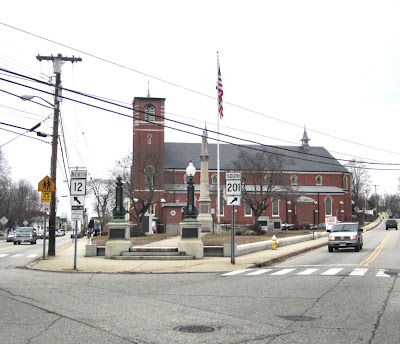
It did not have this intersection, with this church and war memorial, or this established, long-settled feeling.
Every state, even the densely populated coastal ones, has its flyover country. Jewett City, and all the towns like it, are Connecticut's Nebraska. These towns would laugh at you, if they could. They would say,
We've been living here like this all this time, living just fine, not caring if you knew we were here or not. We have a library, and a war memorial, and a park with a gazebo and a little bridge, and they'd all still be here if you'd never seen them, and will remain here if you never come back.

Jewett City would never really say that, because if it could speak it would be too reticent, too polite. But it would think, behind its closed double doors:
Just because you don't see them doesn't mean there are not other places, and other ways, to live.

And yet. Jewett City is a place defined by what it once was, and you can't escape it. Its Main Street, which looked so surprisingly bright and useful and
there on my first drive through, faded a little when I got out to examine it on foot. By the time I left I thought of it as a sort of double place, where everything serves a different purpose from that for which it was intended.

I love places where the past lives on, even where it predominates. But there's a line where the past takes over, where the potential for "historic tourist town" is eclipsed by the signs of former success and the implied subsequent failure. In Jewett City, I thought, the past might have won. If anyone built a building in Jewett City now, it would not be built to last as these older buildings were. There's an optimism in their design, and there was no optimism, at least not visibly, on the borough's streets.

"In the business section," said my book, "a one-legged veteran, member of the local small police force, directs traffic during rush hours."
I drove north again on Route 12. "Descending the side of a heavily wooded hill...State 12 passes
Clayville Pond...in a swampy, stump-marred land. Fragrant pond lilies are offered for sale at roadside stands here in the summer." It sounded like a fairy tale, a lost world. I did not see any of it, but I saw, as I whipped by, a street sign that said "Lily Pond Road."

As I drove I looked for the "Perkins House, built in 1760 by Dr. Elisha Perkins who invented a 'tractor' of knitting needles for massaging sore muscles" [Ed. Note: Ow!] and a c. 1720 salt-box, "the earliest and the most unchanged of the old houses of the town." But I saw nothing worth abruptly stopping to photograph except this sign. It made me think of all the European tourists who come here like pilgrims to drive the remains of old Route 66 in search of crumbling Americana. It would be no use, of course, to tell them that they could find that anywhere, even in Plainfield.

Plainfield was once a busy commercial hub. Railroads between Norwich and Worcester and Providence and Hartford met here, as did the two rivers that powered sprawling mills. Today you can see the legacy of the cash that once flowed here in the spectacular houses with ornate Victorian flourishes, many painted in bright colors, that line Route 12 as it leads from one historic part of town to the next.
"On the western side of the village...are the extensive buildings of the
Lawton Mills, which, prior to liquidation, was the largest textile establishment in eastern Connecticut." At first I saw only the crisscrossing tracks, and on them, train cars of various colors. They could have been pausing there temporarily, waiting for someone to move them along, or they could have been parked this way for decades, I couldn't tell. Pairs of skinny boys in dark hoodies lingered in parking lots or slipped in and out of houses like jumpy ghosts. Finally I glimpsed the familiar red brick outline of a mill building.
The mills here were built in 1905, and powered by steam. This damaged yet resilient relic of that era seemed to be part of, or attached to, a Staples distribution center.

I drove into the parking lot over what looked like a flooded old trolley line, and stood among tractor-less trailers, staring up at broken and boarded windows.

"Across the small Green," the book said, "is the Eaton Tavern (1768.) Washington and Lafayette met at this important stop on the coach line between Providence and Norwich..." I saw a small Green, though the Tavern, if it had been there, was there no longer. But I did find a tank. And really in Connecticut you see places where Washington and Lafayette met all the time, but you don't see a tank parked on the grass every day, do you.
The
Guide described an early 19th century granite church "opposite," and behind that the Plainfield Academy, an acclaimed school where students came from as far as Texas and South America. This is where it got a tad confusing. Because I'd turned to look for the Lawton Mills at the brown sign saying "Lawton Mills Historic District." And there I'd seen the red mill building and the small, well-defended green. But when I later found the Congregational Church, and Academy Lane and Academy Hill Road where presumably the Plainfield Academy buildings once stood, they were nowhere near this. They were further north on Route 12, in the Plainfield Street Historic District. But wait, there's more confusion. The
Guide said all of this (mill, church, school) was located "along State 14." But only the church and erstwhile academy were near Route 14; the mill and green were further south. Was I wrong? Were the authors of
Connecticut: A Guide To Its Roads, Lore, and People wrong? I didn't know.
I continued through Central Village, one of the four villages that make up Plainfield. In 1938 I would have driven "between a double row of maples" on the way to Wauregan, "a mill settlement on the Quinebaug River, clustered around the Wauregan cotton mill."

This was still here, and currently houses a company that manufactures cables. A surprising number of cars, rushing off to somewhere, passed me as I stood looking at it. Though I should have been purely glad to see the mill undamaged and gainfully occupied, in the moment I merely wished that the sturdy building with its almost delicate belfry wasn't marred by an incongruous contemporary awning.

Beside the mill, the workers' houses, too, remained. Their colors appeared cheerfully, almost comically, bright compared with the muted stone of the mill and the white sky. They looked like houses I'd seen in pictures of faraway countries with winters even bleaker than ours, houses painted as if to signal to distant travelers or bring a spot of life to an otherwise frozen landscape.
I kept driving, past what was at the time the book was written a "private waterfowl sanctuary," a "State highway park,
Under the Ash," and the "junction of the Quinebaug and Assawaga Rivers." I'd looked up Assawaga earlier, wondering why I'd never heard of it, and learned it was the old name of the Five Mile River. It means "half-way place," or "place between."

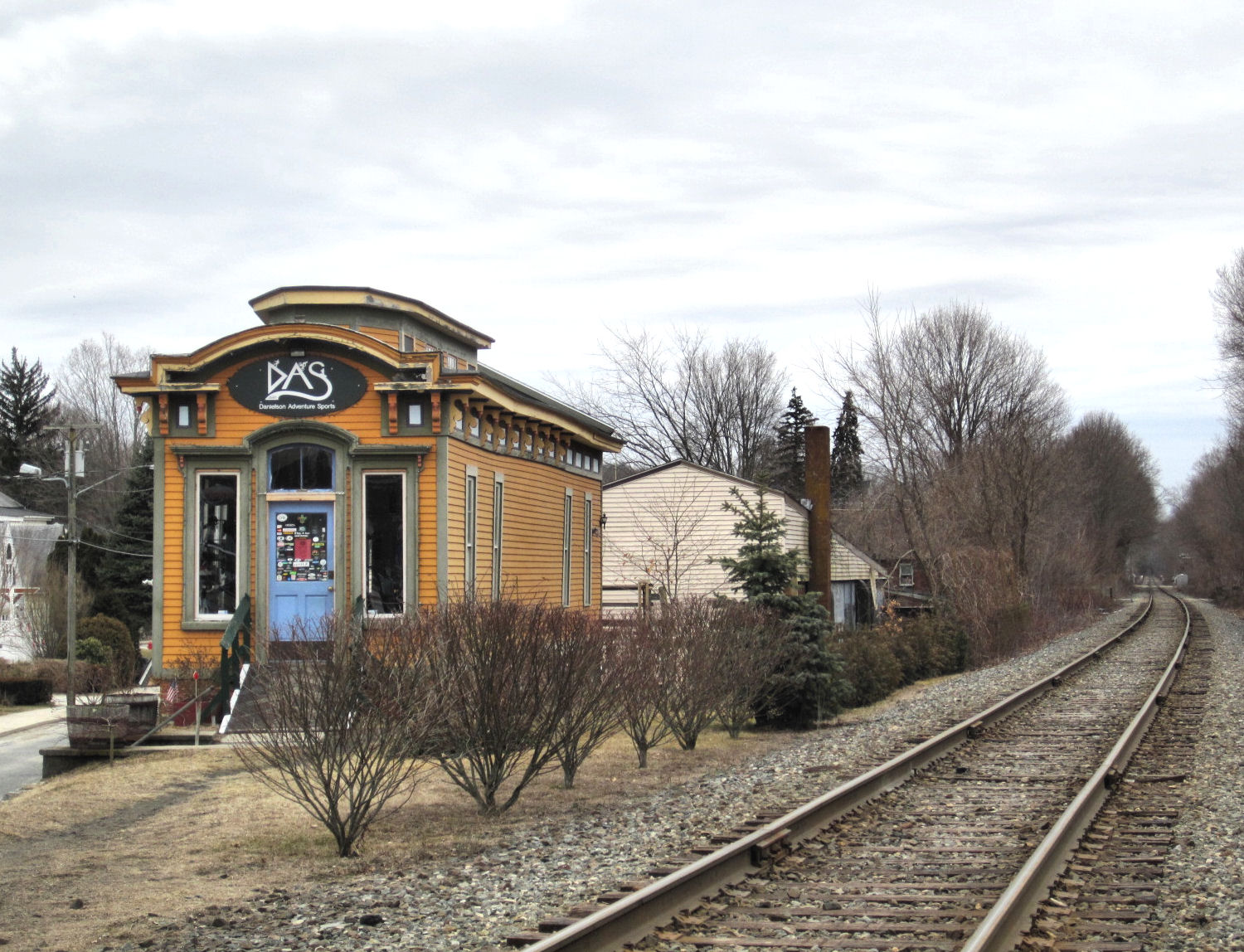
I passed the intersection where I might once have found "the small manufacturing village of Elmville...where sash cord and mill supplies are produced," and came to Danielson, a "bustling manufacturing borough" - of the town of Killingly - "chartered in 1854." And it was, in fact, a little bustling! Just a very little.

As Jewett City had, Danielson popped up at me unexpectedly like one of those elaborate greeting cards that open to reveal a little 3-D city. I know parts of Killingly well, the parts with shopping centers and offices that could be anywhere and that feel like nowhere. Danielson, compared with those and especially compared with the unseen Elmville and the "practically abandoned village of Elliotville" that the
Guide also alleged was somewhere nearby, seemed positively gentrified.
There were mill ruins and rivers here, too; they were hiding somewhere I was sure, if I only looked for them hard enough. But mill ruins and rivers were beginning to blend together in my brain into one big churning waterfall of failure and hope and brick.
So I blew past Killingly Center, "a cluster of small dwellings around the
Jeremiah Fields Tavern," which I doubted was even still there, or still recognizable, or where the book said it would be. This was the site of the Aspinock Quarry, "once used by the Indians from as far west as Michigan as a source of whetstones for shaping arrowheads and utensils."

Because I knew tiny Attawaugan - also part of Killingly - was coming up, I didn't blink. In the book it was "a group of mill houses clustered around a factory," and it still basically is. Stone is still quarried here, though I'd never imagined local rocks like these, which sit in neat rows in a lot by the roadside, shaping arrowheads hundreds of miles away. Looking down at them the expression "dumber than a box of rocks" came to mind, though they were not boxed but fenced together in something more like bales.
Down the road from here, the
Guide said, on an "improved rural road" which is now just a regular old paved street, was Alexander Lake. The Indians said it "arose from the earth, engulfing a mountain" and swallowing people in the midst of a celebration. In 1720 Nell Alexander came from Scotland and settled by the lake. There's a tale about him and the gold ring he found on the ship that brought him to the New World, how it funded his success as an early Yankee Pedlar. There's another story about Alexander in the book, and how he saw, while traveling this very route on a dark night in 1781, "arched across the sky, a brilliant line of '64 cannon shining like the aurora borealis, with their muzzles pointing south.' Shortly after his return home, news was received of the surrender of Cornwallis."
Alexander Lake was open to the public when the book was written, and it remained so until fairly recently. I was told, while working nearby, that it was closed because "people from Willimantic" kept showing up. I didn't ask what that meant; I didn't want to know.
Back on Route 12, I was about to head into "rolling country" with "fine views of farmland," to a town I'd once lived in and a few I'd never seen.